Cumbres Pass to Wolf Creek Pass: June 12th - June 17th, 2025
* Day 0: Zero day in Chama. Breakfast at Fina's Diner with ASAP - chicken fried steak with an egg and hash browns. ASAP is heading home tomorrow, with a pretty battered body and proud of completing the entire New Mexico section. Apparently he's been pulling 20 mile days so more power to him. We talk about family and coffee and how he's donated over 200 pints of blood. Laundry, groceries, lunch, watching daytime TV; I think every other ad is for some new pharmaceutical and every other one of those has group dance numbers. Somehow all the chores are getting done and it's not even getting too late. Sew the small hole in my pants. C4 Farms burger truck for dinner - Susan's green chile cheese steak sandwich disappears in a blink. More popcorn and cereal. We like zero days.

* Day 1: Go to Wilder bakery before leaving. Delicious, buttery, rich, scratch-made pastries, the best coffee I've had since we left Omaha - I need no more reason to travel than a cozy local bakery. Have breakfast with Scorpion Queen, who's leaving today also, and her boyfriend Ragnar picks us up in his Toyota 4Runner/house and gives us a ride up to Cumbres Pass - convenient! Get started by 9:30 AM. Along the way Ragnar picks up Airplane, another hiker who apparently started at the border on April 20th - Susan and I think we might recognize him. Airplane had been biding his time in Utah, waiting for the snow to melt so he could hike the Red Line. We're all heading up to Wolf Creek Pass (then Pagosa Springs) through the southernmost reaches of the San Juan mountains. Apparently 2 weeks ago a heinous amount of snow guarded the trail and pretty much everyone bailed to alternate routes. 1 week ago the snow was obnoxious but barely tolerable. Now it seems our path is almost entirely melted out (but still pretty boggy), and we have 5 solid days of beautiful weather, without even the afternoon thunderstorms characteristic of the area in "good" weather. What fortunate timing. Bright blue skies above us the whole steady climb up from Cumbres pass, through aspens then lodgepole then fir, and then above treeline, where patches of evergreen shrubs stand resolute around the straw-green spring grasses. Deep valleys with steep brown rocky sides rise up to rolling pyramidal peaks. At 12,000 feet we're a thousand feet higher than any part of the trail in New Mexico and it shows, as if at the Colorado border someone flipped a switch to activate the Rocky Mountains; they even have marmots here, we see one scamper over a rock the same shade of dark brown. A steady wind occasionally whips up into gusts that try to steal my hat. Up and over Flat Mountain, down through our first bit of snow on the other side, to a lovely sheltered campsite near Three Lakes. The easiest first day we've had yet.


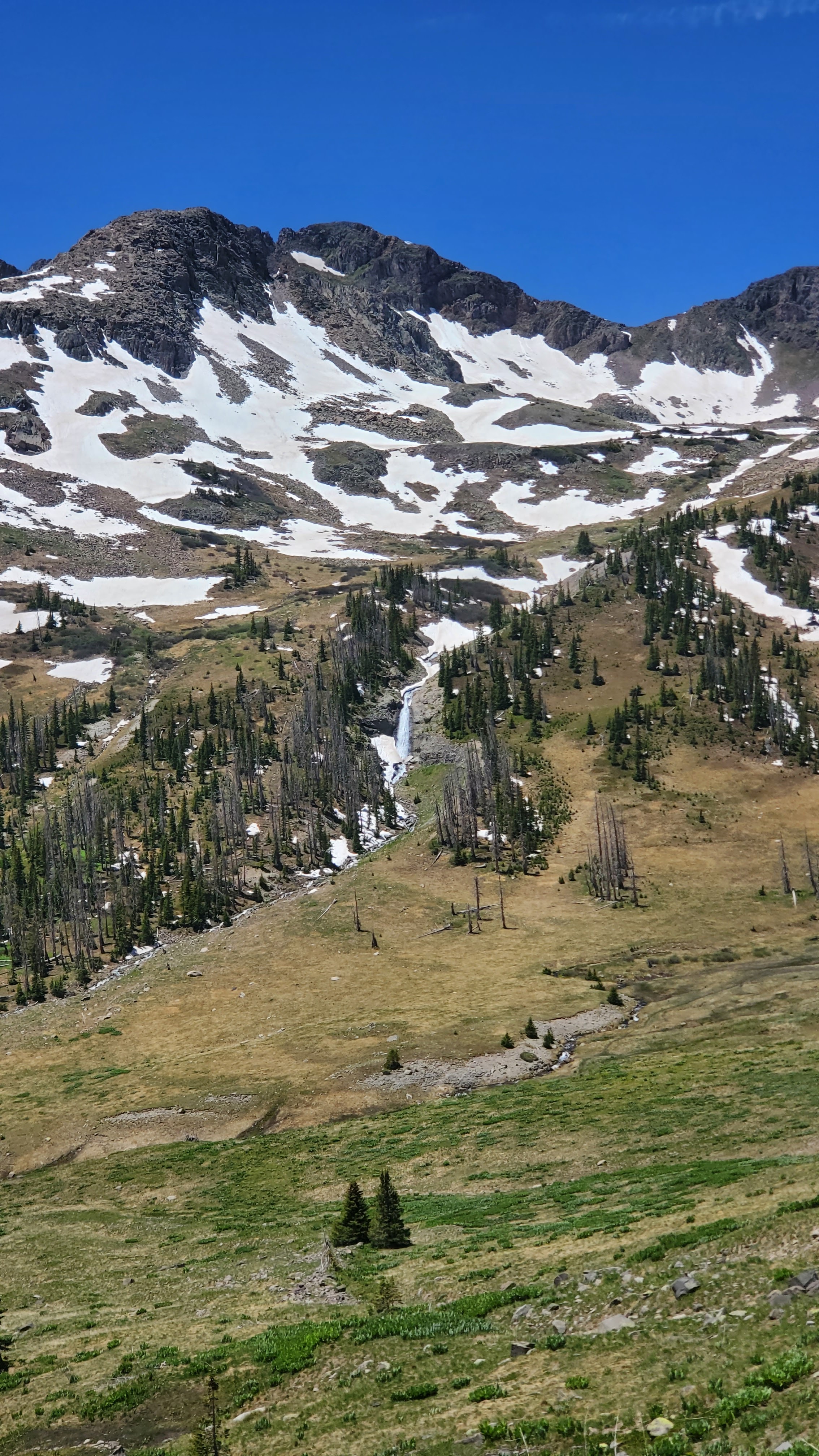
* Day 2: Warmer overnight and in the morning than expected, and the tent is even dry. A neighbor joined us overnight - Low Branch, a hiker from South Carolina who we'd heard a bit about because he spent two or three days off-trail battling a nasty stomach bug (either at Chama's Y Motel or in the picnic pavilion back at Hopewell Lake - unclear). He heads out before us (because we are incapable of doing anything without enjoying some morning coffee). I'm quickly bummed because our first order of business is to walk through the boggy area that normally separates the lakes from each other as land, but is currently swollen with snowmelt. Wet feet wet feet. Down to Dipping Lakes then back up above treeline. In to and out of and around snowbanks, looking for the dryest bits of grass in bogs; I begin asking myself "Can my feet get any less dry?" and often tromp through puddles. Astounding views of mountains, snow still casting their curves in relief, roll on. We bounce around Low Branch all day - he's struggling with the altitude. Apparently three years ago he sustained an injury on the trail a couple hundred miles north and had to self-evac. Lose the trail over a mountain pass, send an elk mom and calf bounding off in the distance, find the trail again off and on through snow and marsh. A couple miles of dry hard-pack remind us that, yes, sometimes hiking is easy, and then the last three-quarter miles or so to Blue Lake are a total junk show. The obscure trail seems to wind up a hillside between downed trees, steep snow, and bands of cliffs. We opt out and bushwhack down to a marsh, then cut across to rejoin the trail. I ford one small stream straight in my shoes. What have I become. Cold and wet and achy feet. Finally make it to Blue Lake and some nice camping by a weird old chimney. Hard to get water though. My shoes won't dry out before morning. A chorus of frogs lulls us to sleep.


Blue Lake


* Day 3: Wake up at Blue Lake. Susan said she could hear Low Branch coughing and throwing up in the morning. She checks on him and he says he's taking the alternate trail down to the road due to altitude sickness. The altitude is getting to me this morning also - slow to get ready. Not feeling great, kinda nauseas. We climb up away from Blue Lake, past another pond, and then cut a steep diagonal across a high-angle grassy slope. I'm nervous because this portion of the route skirts high around a bowl of cliffs and there could be a snow hazard. But as we reach the final contour line and start to hike over the top the snow reveals strategically placed patches of bare ground that afford safe passage. The steep switchbacks down go quickly as we take shortcuts downhill through the snow. One sketchy snow bridge, I chuck a rock at it, the rock tumbles and slides instead of sinking, and we cross. I'm elated because the whole bit was relatively safe and went better than expected. Now we have to do it again: traverse a bowl, up a side-hill, over a mountain shoulder, and pick our way down the other side. The way up faces south and our shoes grip dry soil. The way down faces north and is a treacherous maze of cliffs, trees, and half-thawed snow gullies. More complicated this time - slower. But most snow fields are pretty chill and only a few demand much attention. Snow bridges are out over the next swollen cascade, but we find a flat spot to ford higher up. Nice long break in the shade. Still feeling pretty good. Now for a third time - up the side of the hill. Do a bunch of squiggling traverses up high on a really cool trail. The thin band cut into the steep hillside weaves around one peak and we briefly pop onto the headwall of the Rio Blanco canyon, passing across the top of it as if looking in from a window, the forested floor guarded by intricate bands of grey-tan cliffs and snow gullies. Round another corner; traverse another bowl. Finally hit the sharp hairpin that directs us down another descent. Another north facing slope, another complicated snow situation. I gazed longingly at the Adams Fork Conejos River far below, knowing that our campsite would lay beside it. Cross a snow field that finally gives me the spooks and get the feeling of watching your shadow stretch out while you still have a long ways to go. The trail just keeps traversing and traversing and even going a little uphill - the river is no closer. As we get below treeline dense drifts form frozen waves between the trees and hamper our progress. It's mildly sketchy and entirely infuriating so we finally bail off downhill and bushwhack to the marsh, and I walk straight through the river socks and all because I'm beyond caring about anything other than Susan and getting to where I can peel these wet, cold shoes off my squishy feet. We have to trudge up-valley on a fictitious trail to rejoin the CDT; I *did not* realize we needed to hike entirely to the end of this valley when we rounded that corner. Ugh. 14 miles in almost 12 hours - by far our slowest day yet. We're in trouble if tomorrow isn't easier. But we get camp set up by 7:30, gather water, choke down our couscous, clean up, and my feet are warm and dry inside soft socks while the white noise of cascading water roars 100 feet away. I enjoyed the pasqueflowers today, alert and attuned to the sun and fresh from the earth, peppy petals white like the candytuft popping out from a center the same happy shade of yellow as the buttercups.


.jpg)
Susan enjoys a mini-glissade


.jpg)
Fording the river, shoes and all
* Day 4: Not feeling great again in the morning - waking up above 11,000 feet is getting to me. First step is to follow this fork of the river to its end high in the basin above, then head up to the top of the ridge that lays opposite the side of the valley we came down on. The trail takes us back to about 12,600 and meanders around there for most of the day; we continue to dodge and weave around snow fields and marsh, sometimes plowing straight through, under the ruddy, craggy visage of Summit Peak. We don the Microspikes for yet another snow field just hazardous enough to perk up your wits. Feeling rather uncertain and nervous about this turning into a 14-hour day. An orange and black helicopter comes sweeping through the pass ahead of us, then banks right and disappears towards one of the drainages we hiked through yesterday - that's generally a sign that Something Bad has happened in the mountains. Pass two day-hikers chatting with another CDT'er, an older man in a wide brimmed hat and full tan pants with some missing teeth - at first we swear Low Branch somehow got back ahead of us. But this guy has been out traversing these mountains for 7 or 8 days, making about 7 or 8 miles a day, and he bums a ride off the day hikers because this trail has kind of kicked his ass. We're tired too. Finally we descend down to Elwood Pass and back among the trees. A nice long break lets us air out the shoes in the sun, but they seem to have accrued the sour sort of odor that haunts a pair of shoes forever. We try to mentally prepare for 6 more miles of slog and a late arrival. But just like that, the trail is 85% dry and a clear stripe of solid earth cut into the terrain. We practically fly through the remaining miles, happy to trade a few annoying downed trees for splotches of snow. Long hillside traverses lead us down gently and provide viewing platforms to gaze back at the high country we came from. Alpine bowls still holding snow, leading to steep, grey, rocky faces, separated from each other by bony ridges, betray how glaciers scarred and shaped the landscape thousands of years ago, setting Colorado apart from New Mexico long before such a distinction even mattered. We cruise to a creek, devour some ramen bombs, and go one mile further to camp. Stop along the way to admire a group of of elk bounding uphill in a meadow - I wish my legs were that long. Two miles farther in almost 2 less hours than yesterday. The shoes are finally dry but too smelly to put near the door of the tent. Easiest day since day 1.


Looking up the rest of the valley in the morning
* Day 5: Wake up at Bonito Pass. Trail remains relatively mellow, easy to follow, and *dry*. Mostly below treeline. Some new flowers appear. As we move farther north ski lift stations and cabins pop up on the ridges. Hiking along the ridge of Wolf Creek Ski Area I look back and am treated to the sweeping view so many skiers must have enjoyed as they exited the lifts. I can still see Montezuma and Summit Peaks, looming over their glacial basins, abstracted by the distance; then I realize Susan and I just spent 5 days hiking through the very heart of these mountains, knowing them from different angles, and I know what lies behind those two peaks. Stop in an open but vacant ski patrol hut to take a telehealth call. After some switchbacks, just to stretch things out, we finally arrive at Wolf Creek Pass. We talk with an older woman, Velociraptor, who's about to section hike this part with her friend; they've section hiked all of New Mexico together over the last few years. After we don't get a hitch for about 30 minutes they rearrange the Porsche, cramming duffels and backpacks and coolers and cardboard recycling in every space they'll fit, and give us a lift down to Pagosa Springs. We happily provide them with all the info they could want and wish them the best on that section of trail. A friendly construction flagger helps us find the bus stop with the blown-down sign, and the friendly bus driver drops us literally right outside our hotel. Check into the Alpine Inn, shower, have dinner at a pretty mid brewery because we don't want to cough up for the $40 entrée place. Our new town ritual is popcorn, Gatorade, and cereal - I've never appreciated a Speedway convenience store so much.


Comments
Post a Comment